G.I.S KS3
GIS describes a range of information that is gathered and applied to maps. There can be lots of layers of information applied to the same map. This helps people compare a variety of information for one area.
Lesson Ideas Link GIS the following lessons:
Mapping Crime Activity Idea https://sites.google.com/site/keystage3geographynow/year-9-home/crime/mapping-crime |
Aims The National Curriculum
The national curriculum for geography aims to ensure that all pupils: develop contextual knowledge of the location of globally significant places – both terrestrial and marine – including their defining physical and human characteristics and how these provide a geographical context for understanding the actions of processes understand the processes that give rise to key physical and human geographical features of the world, how these are interdependent and how they bring about spatial variation and change over time are competent in the geographical skills needed to: collect, analyse and communicate with a range of data gathered through experiences of fieldwork that deepen their understanding of geographical processes interpret a range of sources of geographical information, including maps, diagrams, globes, aerial photographs and Geographical Information Systems (GIS) communicate geographical information in a variety of ways, including through maps, numerical and quantitative skills and writing at length. Geographical skills and fieldwork build on their knowledge of globes, maps and atlases and apply and develop this knowledge routinely in the classroom and in the field interpret Ordnance Survey maps in the classroom and the field, including using grid references and scale, topographical and other thematic mapping, and aerial and satellite photographs use Geographical Information Systems (GIS) to view, analyse and interpret places and data use fieldwork in contrasting locations to collect, analyse and draw conclusions from geographical data, using multiple sources of increasingly complex information. |

Using GIS Across Key Stage 3 RGS Ideas
|
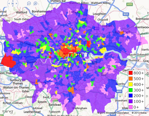
Fieldwork using GISYou tube video of a class collecting field data and returning to the class to plot that data in order to make comparisons using GIS.
http://www.schoolsworld.tv/node/734 |
Overview from TES
|
